
Tracking the Tropics: 2025 Hurricane Season Set to Surge
- Meteorologist Joseph Cooper

- May 22, 2025
- 4 min read
2025 Offical Nation Hurricane Center (NHC) Forecast
Following a record-breaking 2024 hurricane season, the National Hurricane Center (NHC) has released its official outlook for the 2025 Atlantic hurricane season, which spans from June 1 through November 30. This year, the NHC and NOAA are forecasting another above-average season, expecting between 13 and 19 named storms, with 6 to 10 becoming hurricanes, and 3 to 5 reaching major hurricane status (Category 3 or higher). NOAA places about 70% confidence in these projections. For comparison, an average season typically sees 14 named storms, 7 hurricanes, and 3 major hurricanes.

Colorado State University Forecast and Landfall Probabilities
The Tropical Weather & Climate Research Center at Colorado State University (CSU) is also calling for an active season. Their 2025 outlook predicts 17 named storms, 9 hurricanes, and 4 major hurricanes. In addition to storm counts, CSU's analysis highlights an increased likelihood of landfalling storms. Historically, there’s about a 43% chance of at least one major hurricane striking the U.S. coastline in any given year. This year, that probability rises to 51%.

Breaking it down regionally, CSU estimates a 26% chance of a major hurricane hitting the U.S. East Coast, including the Florida Peninsula, and a 33% chance of a major landfall along the Gulf Coast, from the Florida Panhandle to Brownsville, Texas. Both of these numbers represent a modest but meaningful increase over long-term averages.
Why Is 2025 Expected to Be So Active?
Several key environmental factors are contributing to the outlook for another busy hurricane season. One of the most influential is the continuation of ENSO-neutral conditions, meaning we are neither in an El Niño nor La Niña phase. These neutral conditions often create a more favorable environment for tropical development in the Atlantic.

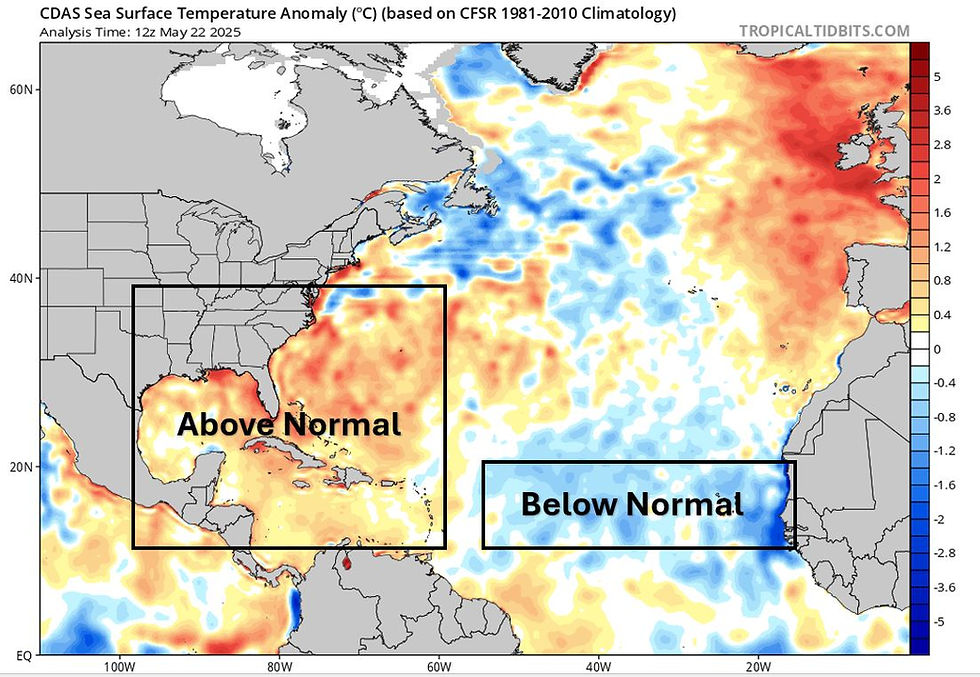
Another major factor is the expectation for warmer-than-normal ocean temperatures, particularly in the Caribbean and Gulf of Mexico. Warm sea surface temperatures serve as fuel for tropical systems. Although the Main Development Region (MDR), which stretches from Africa to the Caribbean is currently experiencing slightly below-average sea surface temperatures, models suggest these waters will warm to near or above normal levels as summer progresses. In contrast, the Caribbean and Gulf are already running above average, and are expected to stay that way throughout the season, enhancing the potential for storm formation or strengthening in those areas.
In addition to warm waters, the forecast also points to weaker vertical wind shear, which allows tropical systems to organize and intensify without being torn apart. A potentially more active West African Monsoon is also noted, which often spawns the tropical waves that evolve into hurricanes as they cross the Atlantic.
The Role of Analog Years in Seasonal Forecasting
Meteorologists use a variety of tools beyond computer models to forecast seasonal activity. One of the most useful is the analysis of analog years, past hurricane seasons that featured similar atmospheric and oceanic conditions. These comparisons can provide valuable insight into what the current season might bring.
According to Colorado State University, the top analog years for 2025 are 1996, 1999, 2006, 2008, 2011, and 2017. These years share characteristics such as being the second year after an El Niño event, exhibiting La Niña conditions during the prior winter, and having above-average sea surface temperatures in the tropical and subtropical Atlantic. These analog years averaged 14.5 named storms, 7.8 hurricanes, and 4.7 major hurricanes.
The website Tropical Tidbits also produces analog comparisons, using sea surface temperature anomalies to identify similar years. Their analysis, which pulls from eight historical seasons, suggests an average of 14.8 named storms, 7 hurricanes, and 2.9 major hurricanes. These analogs indicate an increased likelihood of storm activity affecting the Florida Keys, southeastern United States, and central Gulf Coast.

While helpful, it’s important to remember that analogs are only one piece of the puzzle. They are used to supplement, not replace, modern forecasting tools or meteorologists, and should always be interpreted with caution.
Key Takeaways and Considerations
Confidence is high that 2025 will be another active Atlantic hurricane season, driven by warm ocean waters, minimal wind shear, and a favorable pattern for storm development. However, one potential caveat is the cooler-than-average temperatures in the MDR, which could slow early-season activity. Still, forecasts strongly suggest these waters will warm as the season progresses.
Preparedness and Reminders
The National Hurricane Center began issuing daily outlooks for the Atlantic Basin on May 15, including both 2-day and 7-day graphical forecasts. These updates serve as the official source for tropical weather information.
As always, it’s essential to rely on trusted sources such as the NHC and your local National Weather Service office. Be wary of exaggerated or fear-inducing posts on social media.
Knowing your evacuation zone and understanding the risks of storm surge, inland flooding, and tornadoes, not just wind, is key to being prepared. It’s worth noting that storm surge is historically the deadliest component of tropical systems.
Follow Us for the Latest Updates!
As the season unfolds, we’ll be posting timely forecasts, analysis, and breaking updates across our social media channels. Be sure to follow us for the latest and most accurate hurricane information all season long.
Thermodynamic Solutions (“TDS Weather”) provides professional weather consulting services to a variety of industries including: professional and minor league sports, snow removal and landscaping, golf courses and turf management, colleges and universities, and hospital networks. With nearly two decades of living and forecasting in the Ohio Valley region, our meteorologists provide custom, reliable forecasts that help clients SAVE and MAKE money in their daily operations. Our services include commercial and agricultural forecasting in the short and long ranges, lightning alerts and on-site hazardous weather monitoring, 24/7 on-call decision support services, forensic weather reporting, and more! For weather consulting inquiries, please contact us at info@tdsweather.com.


Using technology to increase access to youth mental health support may offer a practical way for young people to reach guidance, safe-spaces, and early help without feeling overwhelmed by traditional systems. Digital platforms, helplines, and apps could give them a chance to seek support privately, connect with trained listeners-orexplore resources that might ease their emotional load. This gentle shift toward tech-based support may encourage youth to open-up at their own pace, especially when in-person help feels too heavy to approach.
There is always a chance that these tools-quietly make support feel closer than before, creating moments where help appears just a tap away. Even a small digital interaction might bring a sense of comfort. And somewhere in that space, you…
Detailed and practical, this guide explains concrete rebar in a way that feels approachable without oversimplifying. The step by step clarity is especially useful for readers new to the subject. I recently came across a construction related explanation on https://hurenberlin.com that offered a similar level of clarity, and this article fits right in with that quality. Great شيخ روحاني resource. explanation feels practical for everyday rauhane users. I checked recommended tools on https://www.eljnoub.com
s3udy
q8yat
elso9
I recently saw the Stussy Dragon Hoodie and was impressed by its unique design. The Stussy Green Hoodie is another option I liked, offering a refreshing tone. Stussy Jacket makes it easy to find creative yet wearable styles like these.
Represent the legacy with the official Yellowstone Dutton Ranch Jacket. This jacket is a symbol of the land and family that Rip Wheeler protects. It's a powerful piece for any fan and a great addition alongside a Rip Wheeler Outfit.